Join Augustin, Alex, Lisa and the whole ArkeoTopia team to discover additional resources for step 5.3 in My archaeology book about underwater excavation, one of the method in archaeology.
Step 5.3 – Fieldwork
Underwater Excavation
Corresponding pages in MAB1 and MAB2
MCA 1, p. 17 and MCA 2, pp. 22-23
More about the step’s reference artifact
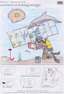
 The drawing in My Archaeology Book titled Underwater Archaeology was inspired by the shipwreck of the Astrolabe, which lies in the sea at a site near Paeu, Vanikoro called “the fault.” These archaeological remains illustrate a method of archaeological excavation that helps archaeologists study the former presence of humans.
This page explores the idea that some archaeological remains may be underwater. This is the case for sunken ships and crashed airplanes, but also for human settlements submerged in water, such as prehistoric dwellings found in and around lakes and marshes, more recent buildings such as the Byzantine basilica possibly dating back to 4th century CE located in Lake Iznik (in the Province of Bursa, Turkey) and entire city blocks, like the fortified zone of Borj El Hassar, with its quays and its lighthouse, on the Kerkennah Islands in Tunisia.
Archaeologists need to gear up for underwater excavations. In addition to wearing a wetsuit and scuba tanks, they need tools adapted to underwater use: floats to locate the remains, water-dredges or airlifts to clear off the remains, string bags to store small artifacts of interest and lift bags to bring them to the surface, and photography and drawing equipment that works underwater. Accompanied by Dona, the female dolphin, Alex the archaeologist fills in the grid’s A3 box with the remains from the shipwreck of the Astrolabe at Vanikoro in Solomon Islands (Pacific Ocean).
 The drawing was inspired by a similar drawing showing the Astrolabe shipwreck as seen on page 48 of the report from 1999 entitled Lapérouse at Vanikoro, Results from the latest Franco-Solomon Islander research in the Santa Cruz islands, published in 2003.
 Fascinated by the voyages undertaken by the British explorer and cartographer James Cook between 1768 and 1779, King Louis XVI of France entrusted the Count of La Pérouse with organizing a voyage of circumnavigation (navigating a boat all the way around a place, in this case around Earth). Two frigates were charged with crisscrossing the globe to explore new lands and amass scientific observations. Under the command of Jean-François de la Pérouse (1741-1788) and Paul Fleuriot de Langle (1744-1787), respectively, the frigates Boussole and Astrolabe set off from Brest on August 1, 1785. Each ship set sail with around one hundred and ten men on board: senior officers and mariners, gunners, sailors and servants, but also a handful of scientists and renowned scholars. On March 10, 1788, after a final stopover on the Australian coast, in Botany Bay near Sydney, the Frenchmen weighed anchor, setting off on one last mission before the long journey back to Europe. They aimed to gain reconnaissance on the western coast of New Caledonia and the surrounding territories. The two frigates and their crews were never heard from again, until 1827, when the British captain Peter Dillon discovered evidence of the expedition’s tragic end on the reefs of Vanikoro in the Solomon archipelago.
Today, archaeological remains from various excavation campaigns dating back to 1981 are on display at the Maritime Museum of New Caledonia in Noumea and online at www.collection-laperouse.fr/en and include the Mercier sextant from step 7.2 on pages 40-41 of My Archaeology Book (see step 7.2).
The clues
The idea here is to illustrate how excavations unfold and what tools archaeologists use underwater.
The 8 clues include:
- Alex as a diver with the wetsuit – mask – ballasts – scuba tank – depth gauge – flippers – a knife for self-defense
- The slate and pencil to complete a field survey
- The string bag with holes to easily bring up through the water the archaeological remains found on-site
- The float to mark the presence of archaeological remains (here, a plate)
- Dona, the female dolphin
- The grid of the shipwreck’s excavation and the labels
- Anchors which represent some of the visible archaeological remains
- Cannons which represent some of the visible archaeological remains
StratigraphyMy Archaeology Book
Resources HomepageStep 5.4 – Fieldwork
Land-Based Excavation


